


وصف لـ Distance - Find My Area/Distance
Draw to measure distance along the map, made easy with this app. Now with area measurement and custom coefficients.
Usage
-------
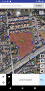
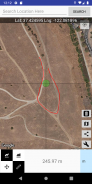
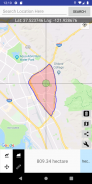
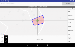
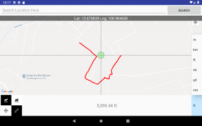
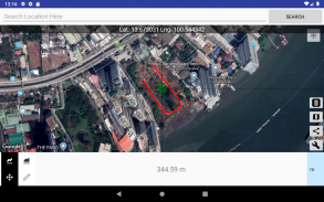
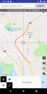
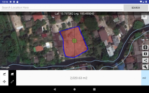
By simply touching. Draw a route on the map to find its distance / area. Magnifier will help you make precise drawing and measurement.
◆ Switch between Move and Measure mode. So you can pick where you want to begin measurement or begin right away. You can keep moving the map and continue measure longer distance.
◆ Switch between Area and Distance calculation.
◆ Press "Unit" button to change display units.
◆ Press "Undo" button to make any changes
◆ Press "Share" button to export result (with screenshot) to Twitter, Camera roll, Email, and much more.
◆ Press “Search” button to search for desired location. Please type in coordinates value, MGRS, NACS, Web Mercator, and many more. Or search location by name of place, city, state, or country.
Note: Distance and Area are calculate based on the earth curvature.
رسم لقياس المسافة على طول الخريطة ، أصبح سهلا مع هذا التطبيق. الآن مع قياس المساحة والمعاملات المخصصة.
استعمال
-------
ببساطة عن طريق اللمس. ارسم طريقًا على الخريطة للعثور على مسافة / منطقة. سوف المكبر تساعدك على جعل الرسم والقياس الدقيق.
between التبديل بين وضع التحرك والقياس. حتى تتمكن من اختيار المكان الذي تريد أن تبدأ القياس أو تبدأ على الفور. يمكنك الاستمرار في تحريك الخريطة ومتابعة قياس المسافة الأطول.
◆ التبديل بين حساب المنطقة والمسافة.
◆ اضغط على زر "الوحدة" لتغيير وحدات العرض.
◆ اضغط على زر "تراجع" لإجراء أي تغييرات
◆ اضغط على زر "مشاركة" لتصدير النتيجة (مع لقطة شاشة) إلى Twitter ولفة الكاميرا والبريد الإلكتروني وغير ذلك الكثير.
◆ اضغط على زر "بحث" للبحث عن الموقع المطلوب. يرجى كتابة قيمة الإحداثيات ، MGRS ، NACS ، Web Mercator ، وغيرها الكثير. أو ابحث في الموقع حسب اسم المكان أو المدينة أو الولاية أو البلد.
ملاحظة: يتم حساب المسافة والمساحة بناءً على انحناء الأرض.
Distance - Find My Area/Distance - إصدار 1.4.5
(04-12-2023)Distance - Find My Area/Distance - معلومات APK
نُسخة APK: 1.4.5الحزمة: com.myice92.distanceتطبيقات من الفئة نفسها
قد يعجبك أيضًا...


